
ھۆججەت:LanguageMap-Lingala-Larger Location.png
يۇقىرىراق پەرق ئېتىش نىسبىتى يوق.
LanguageMap-Lingala-Larger_Location.png (388 × 341 پىكسېل، ھۆججەت چوڭلۇقى: 13 KB، MIME تىپى: image/png)

|
This linguistic map image could be re-created using vector graphics as an SVG file. This has several advantages; see Commons:Media for cleanup for more information. If an SVG form of this image is available, please upload it and afterwards replace this template with
{{vector version available|new image name}}.
It is recommended to name the SVG file “LanguageMap-Lingala-Larger Location.svg”—then the template Vector version available (or Vva) does not need the new image name parameter. |
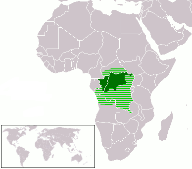
- Dark Green: Lingala native speakers
- Light Green: Area where Lingala is sometimes used
| I, the copyright holder of this work, release this work into the public domain. This applies worldwide. In some countries this may not be legally possible; if so: I grant anyone the right to use this work for any purpose, without any conditions, unless such conditions are required by law. |
ھۆججەت تارىخى
چېسلا/ۋاقىت چېكىلسە ئەينى ۋاقىتتا كۆرۈلگەن ھۆججەتنى كۆرسىتىدۇ.
| چېسلا/ۋاقىت | كىچىك سۈرەت | ئۆلچەم | ئىشلەتكۈچى | ئىزاھات | |
|---|---|---|---|---|---|
| نۆۋەتتىكى | 19:38, 8 مارت 2018 | | 388 × 341 (13 KB) | Maphobbyist | Check |
| 19:33, 8 مارت 2018 |  | 388 × 341 (13 KB) | Maphobbyist | South Sudan border | |
| 06:18, 13 ئاپرېل 2012 |  | 388 × 341 (16 KB) | Hoshie | added South Sudan and Cabinda (Angola). Under same Lic. | |
| 03:19, 12 ئاپرېل 2005 |  | 388 × 341 (6 KB) | Moyogo | better colours | |
| 03:13, 12 ئاپرېل 2005 |  | 388 × 341 (6 KB) | Moyogo | Lingala Language * Dark Green: Lingala native speakers * Light Green: Area where Lingala is sometimes used {{PD}} Category:Linguistic maps |
ھۆججەت ئىشلىتىلىشى
تۆۋەندىكى بەت بۇ ھۆججەتنى ئىشلىتىدۇ:
ئورتاق ھۆججەت ئىشلىتىلىشى
تۆۋەندىكى باشقا ۋىكىلار بۇ ھۆججەتنى ئىشلىتىدۇ:
- af.wikipedia.org دىكى ئىشلىتىشى
- als.wikipedia.org دىكى ئىشلىتىشى
- am.wikipedia.org دىكى ئىشلىتىشى
- ar.wikipedia.org دىكى ئىشلىتىشى
- ast.wikipedia.org دىكى ئىشلىتىشى
- bn.wikipedia.org دىكى ئىشلىتىشى
- br.wikipedia.org دىكى ئىشلىتىشى
- ca.wikipedia.org دىكى ئىشلىتىشى
- ckb.wikipedia.org دىكى ئىشلىتىشى
- cy.wikipedia.org دىكى ئىشلىتىشى
- de.wikipedia.org دىكى ئىشلىتىشى
- el.wiktionary.org دىكى ئىشلىتىشى
- en.wikipedia.org دىكى ئىشلىتىشى
- eo.wikipedia.org دىكى ئىشلىتىشى
- es.wikipedia.org دىكى ئىشلىتىشى
- et.wikipedia.org دىكى ئىشلىتىشى
- eu.wikipedia.org دىكى ئىشلىتىشى
- fr.wikipedia.org دىكى ئىشلىتىشى
- fr.wikivoyage.org دىكى ئىشلىتىشى
- gl.wikipedia.org دىكى ئىشلىتىشى
- id.wikipedia.org دىكى ئىشلىتىشى
- ig.wikipedia.org دىكى ئىشلىتىشى
- ja.wikipedia.org دىكى ئىشلىتىشى
- kbd.wikipedia.org دىكى ئىشلىتىشى
- kg.wikipedia.org دىكى ئىشلىتىشى
- ko.wikipedia.org دىكى ئىشلىتىشى
- kv.wikipedia.org دىكى ئىشلىتىشى
- ln.wikipedia.org دىكى ئىشلىتىشى
- lv.wikipedia.org دىكى ئىشلىتىشى
- nl.wikipedia.org دىكى ئىشلىتىشى
- nn.wikipedia.org دىكى ئىشلىتىشى
- no.wikipedia.org دىكى ئىشلىتىشى
- oc.wikipedia.org دىكى ئىشلىتىشى
- pl.wikipedia.org دىكى ئىشلىتىشى
- ps.wikipedia.org دىكى ئىشلىتىشى
- pt.wikipedia.org دىكى ئىشلىتىشى
- qu.wikipedia.org دىكى ئىشلىتىشى
- ru.wikipedia.org دىكى ئىشلىتىشى
- rw.wikipedia.org دىكى ئىشلىتىشى
- sat.wikipedia.org دىكى ئىشلىتىشى
- sk.wikipedia.org دىكى ئىشلىتىشى
- sr.wikipedia.org دىكى ئىشلىتىشى
- sv.wikipedia.org دىكى ئىشلىتىشى
View more global usage of this file.