
ھۆججەت:Malaysia states named.png

بۇ ئالدىن كۆزىتىشنىڭ چوڭلۇقى: 800 × 274 پىكسېل. باشقا چوڭلۇقى: 320 × 109 پىكسېل | 640 × 219 پىكسېل | 1,500 × 513 پىكسېل.
ئەسلى ھۆججەت (1,500 × 513 پىكسېل، ھۆججەت چوڭلۇقى: 163 KB، MIME تىپى: image/png)

|
This map image could be re-created using vector graphics as an SVG file. This has several advantages; see Commons:Media for cleanup for more information. If an SVG form of this image is available, please upload it and afterwards replace this template with
{{vector version available|new image name}}.
It is recommended to name the SVG file “Malaysia states named.svg”—then the template Vector version available (or Vva) does not need the new image name parameter. |
ئۈزۈندە
| چۈشەندۈرۈش |
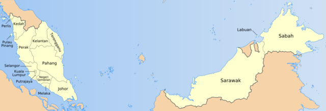
English: Map of the states of Malaysia, named in local terms. |
| چېسلا | |
| مەنبە | Originally own work by uploader based on PD CIA material, using other sources to estimate the borders of Putrajaya. This version is based on File:Malaysia location map.svg |
| يازغۇچى | Golbez, Mdzafri |
ئىجازەت
I, the copyright holder of this work, hereby publish it under the following licenses:

|
Permission is granted to copy, distribute and/or modify this document under the terms of the GNU Free Documentation License, Version 1.2 or any later version published by the Free Software Foundation; with no Invariant Sections, no Front-Cover Texts, and no Back-Cover Texts. A copy of the license is included in the section entitled GNU Free Documentation License. |
| This file is licensed under the Creative Commons Attribution-Share Alike 3.0 Unported license. | ||
| ||
| This licensing tag was added to this file as part of the GFDL licensing update. |
This file is licensed under the Creative Commons Attribution 2.5 Generic license.
- سىز ئەركىن:
- بەھىرلەش – to copy, distribute and transmit the work
- ئۆزگەرتىش – ئىجادىي ئەسەر
- تۆۋەندىكى شەرتلەرگە چوقۇم ئەمەل قىلىڭ:
- ئىمزا – You must give appropriate credit, provide a link to the license, and indicate if changes were made. You may do so in any reasonable manner, but not in any way that suggests the licensor endorses you or your use.
You may select the license of your choice.
ھۆججەت تارىخى
چېسلا/ۋاقىت چېكىلسە ئەينى ۋاقىتتا كۆرۈلگەن ھۆججەتنى كۆرسىتىدۇ.
| چېسلا/ۋاقىت | كىچىك سۈرەت | ئۆلچەم | ئىشلەتكۈچى | ئىزاھات | |
|---|---|---|---|---|---|
| نۆۋەتتىكى | 10:57, 19 ئىيۇل 2009 | 1,500 × 513 (163 KB) | Mdzafri | Corrected error in Perlis labeling and using a more detailed map. | |
| 00:44, 25 يانۋار 2006 | 1,500 × 513 (34 KB) | Golbez | Better location for a couple of names. | ||
| 09:35, 24 يانۋار 2006 | 1,500 × 513 (34 KB) | Golbez | Map of the states of Malaysia, named in English/local terms I think. Made by User:Golbez, based on PD CIA material, using other sources to estimate the borders of Putrajaya. Category:Maps of Malaysia |
ھۆججەت ئىشلىتىلىشى
بۇ ھۆججەتنى ئىشلەتكەن بەت يوق.
ئورتاق ھۆججەت ئىشلىتىلىشى
تۆۋەندىكى باشقا ۋىكىلار بۇ ھۆججەتنى ئىشلىتىدۇ:
- ace.wikipedia.org دىكى ئىشلىتىشى
- an.wikipedia.org دىكى ئىشلىتىشى
- ar.wikipedia.org دىكى ئىشلىتىشى
- az.wikipedia.org دىكى ئىشلىتىشى
- ban.wikipedia.org دىكى ئىشلىتىشى
- bg.wikipedia.org دىكى ئىشلىتىشى
- br.wikipedia.org دىكى ئىشلىتىشى
- csb.wikipedia.org دىكى ئىشلىتىشى
- cs.wikipedia.org دىكى ئىشلىتىشى
- da.wikipedia.org دىكى ئىشلىتىشى
- diq.wikipedia.org دىكى ئىشلىتىشى
- el.wikipedia.org دىكى ئىشلىتىشى
- en.wikipedia.org دىكى ئىشلىتىشى
- en.wikisource.org دىكى ئىشلىتىشى
- eu.wikipedia.org دىكى ئىشلىتىشى
- fa.wikipedia.org دىكى ئىشلىتىشى
- fi.wikipedia.org دىكى ئىشلىتىشى
View more global usage of this file.