ھۆججەت:Tamil speakers map.svg

Page contents not supported in other languages.
ئورنى Wikipedia

ئەسلى ھۆججەت(SVG ھۆججىتى، ئاتاقتىكى چوڭلۇقى 1,639 × 1,852 نۇقتا، ھۆججەت چوڭلۇقى: 260 KB)

بۇ ھۆججەت ۋىكى ۋاستە ھەمبەھىر دىن كەلگەن، ئۇ باشقا قۇرۇلۇشتا ئىشلىتىلىشى مۇمكىن. ھۆججەت چۈشەندۈرۈش بېتى نىڭ چۈشەندۈرۈشى تۆۋەندە كۆرسىتىلىدۇ.

ئۈزۈندە

Title
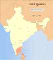
Tamil speakers map
Description
Areas in India and Sri Lanka where Tamil is spoken.
SVG genesis
InfoField
 
The SVG code is valid.
 
This map was created with Inkscape.
 
 This map uses embedded text that can be easily translated using a text editor.
چېسلا
مەنبە

ئۆز ئەسىرىم
International Borders: University of Texas map library - India Political map 2001
Disputed Borders: University of Texas map library - China-India Borders - Eastern Sector 1988 & Western Sector 1988 - Kashmir Region 2004 - Kashmir Maps.
State and District boundaries: Census of India - 2001 Census State Maps - Survey of India Maps.
Other sources: US Army Map Service, Survey of India Map Explorer, Columbia University

Map specific sources: Himalag - Language families and dialects in South Asia map.
Creator
ھوقۇق
(بۇ ھۆججەتنى قايتىلاپ ئىشلىتىش)
I, the copyright holder of this work, hereby publish it under the following license:
w:en:Creative Commons
ئىمزا ئوخشاش ئۇسۇلدا بەھىرلەش
This file is licensed under the Creative Commons Attribution-Share Alike 3.0 Unported license.
سىز ئەركىن:
  • بەھىرلەش – to copy, distribute and transmit the work
  • ئۆزگەرتىش – ئىجادىي ئەسەر
تۆۋەندىكى شەرتلەرگە چوقۇم ئەمەل قىلىڭ:
  • ئىمزا – You must give appropriate credit, provide a link to the license, and indicate if changes were made. You may do so in any reasonable manner, but not in any way that suggests the licensor endorses you or your use.
  • ئوخشاش ئۇسۇلدا بەھىرلەش – If you remix, transform, or build upon the material, you must distribute your contributions under the same or compatible license as the original.

The frontiers depicted on the Indian maps in Wikipedia are from a neutral point of view and may differ from official government maps of India, Pakistan and China. Please consult local laws governing publication of maps before usage.
 Geotemporal data
Date depicted second half of 20 century ۋە 21 century
Georeferencing Georeference the map in Wikimaps Warper If inappropriate please set warp_status = skip to hide.
 Archival data
ئىزاھ Part of WikiProject India Maps

Captions

Add a one-line explanation of what this file represents

Items portrayed in this file

depicts ئىنگلىزچە

copyright status ئىنگلىزچە

copyrighted ئىنگلىزچە

source of file ئىنگلىزچە

original creation by uploader ئىنگلىزچە

media type ئىنگلىزچە

image/svg+xml

ھۆججەت تارىخى

چېسلا/ۋاقىت چېكىلسە ئەينى ۋاقىتتا كۆرۈلگەن ھۆججەتنى كۆرسىتىدۇ.

چېسلا/ۋاقىتكىچىك سۈرەتئۆلچەمئىشلەتكۈچىئىزاھات
نۆۋەتتىكى14:26, 17 مارت 202214:26, 17 مارت 2022 نىڭ كىچىك سۈرەت نەشرى1,639 × 1,852 (260 KB)Sebastian Wallrothborder minimized
11:34, 14 سىنتەبىر 202111:34, 14 سىنتەبىر 2021 نىڭ كىچىك سۈرەت نەشرى512 × 577 (291 KB)AmritsvārayaUpdated the map to 1981
11:22, 27 ئاپرېل 200711:22, 27 ئاپرېل 2007 نىڭ كىچىك سۈرەت نەشرى1,639 × 1,852 (344 KB)Planemad{{WikiProject_India_Maps |Title=Tamil speakers map |Description=Areas in India and Sri Lanka where Tamil is spoken. |Source= [http://www.iitg.ernet.in/rcilts/assam_political.jpg IIT Guwahati - Assam Political map] |Date=April 2007 |Author=[[w:user:Pl

بۇ ھۆججەتنى ئىشلەتكەن بەت يوق.

ئورتاق ھۆججەت ئىشلىتىلىشى

تۆۋەندىكى باشقا ۋىكىلار بۇ ھۆججەتنى ئىشلىتىدۇ:

مېتامەلۇمات