
ھۆججەت:Ciudades de Sumeria.svg

Size of this PNG preview of this SVG file: 465 × 512 پىكسېل. باشقا چوڭلۇقى: 218 × 240 پىكسېل | 436 × 480 پىكسېل | 697 × 768 پىكسېل | 930 × 1,024 پىكسېل | 1,860 × 2,048 پىكسېل.
ئەسلى ھۆججەت (SVG ھۆججىتى، ئاتاقتىكى چوڭلۇقى 465 × 512 نۇقتا، ھۆججەت چوڭلۇقى: 180 KB)
ئۈزۈندە
| چۈشەندۈرۈش |
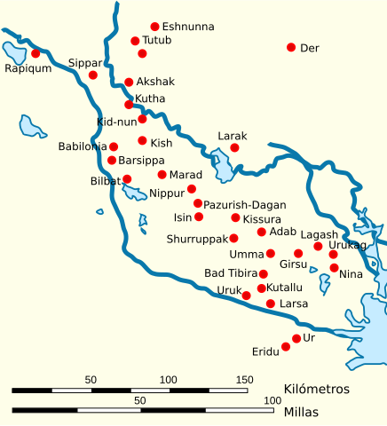
Español: Mapa de la localización de las principales ciudades de Sumeria y Elam |
| چېسلا | |
| مەنبە | ئۆز ئەسىرىم, based on this work by User:John D. Croft |
| يازغۇچى | Crates |
| ھوقۇق (بۇ ھۆججەتنى قايتىلاپ ئىشلىتىش) |
CC-BY |
| Other versions |
[]
|

.svg)

.svg)
.svg)

.svg)


.svg)

.svg)
ئىجازەت
I, the copyright holder of this work, hereby publish it under the following licenses:

|
Permission is granted to copy, distribute and/or modify this document under the terms of the GNU Free Documentation License, Version 1.2 or any later version published by the Free Software Foundation; with no Invariant Sections, no Front-Cover Texts, and no Back-Cover Texts. A copy of the license is included in the section entitled GNU Free Documentation License. |
This file is licensed under the Creative Commons Attribution 3.0 Unported license.
- سىز ئەركىن:
- بەھىرلەش – to copy, distribute and transmit the work
- ئۆزگەرتىش – ئىجادىي ئەسەر
- تۆۋەندىكى شەرتلەرگە چوقۇم ئەمەل قىلىڭ:
- ئىمزا – You must give appropriate credit, provide a link to the license, and indicate if changes were made. You may do so in any reasonable manner, but not in any way that suggests the licensor endorses you or your use.
You may select the license of your choice.
ھۆججەت تارىخى
چېسلا/ۋاقىت چېكىلسە ئەينى ۋاقىتتا كۆرۈلگەن ھۆججەتنى كۆرسىتىدۇ.
| چېسلا/ۋاقىت | كىچىك سۈرەت | ئۆلچەم | ئىشلەتكۈچى | ئىزاھات | |
|---|---|---|---|---|---|
| نۆۋەتتىكى | 10:04, 12 مارت 2017 | | 465 × 512 (180 KB) | Rowanwindwhistler | https://en.wikipedia.org/wiki/Wikipedia:WikiProject_Maps/Conventions Fake text added |
| 16:25, 9 فېۋرال 2011 |  | 436 × 480 (59 KB) | Phirosiberia | Translation | |
| 16:19, 9 فېۋرال 2011 |  | 436 × 480 (59 KB) | Phirosiberia | Scale added | |
| 20:30, 18 يانۋار 2009 |  | 436 × 480 (62 KB) | Phirosiberia | {{Information |Description= |Source= |Date= |Author= |Permission= |other_versions= }} | |
| 20:29, 18 يانۋار 2009 |  | 436 × 480 (67 KB) | Phirosiberia | {{Information |Description= |Source= |Date= |Author= |Permission= |other_versions= }} | |
| 15:54, 12 فېۋرال 2008 |  | 436 × 480 (62 KB) | Phirosiberia | == Sumario == {{Information |Description={{es|Mapa de la localización de las principales ciudades de Sumeria y Elam}} |Source=self-made |Date=2008-01-21 |Author= Crates |Permission=PD-self |other_versions= }} Category:Sumer [[Categor | |
| 13:25, 1 فېۋرال 2008 |  | 442 × 482 (62 KB) | Phirosiberia | {{Information |Description={{es|Mapa de la localización de las principales ciudades de Sumeria y Elam}} |Source=self-made |Date=2008-01-21 |Author= Crates |Permission=PD-self |other_versions= }} Category:Sumer [[Category:Maps of the | |
| 13:12, 1 فېۋرال 2008 |  | 440 × 480 (83 KB) | Phirosiberia | {{Information |Description={{es|Mapa de la localización de las principales ciudades de Sumeria}} |Source=self-made |Date=2008-01-21 |Author= Crates |Permission=PD-self |other_versions= }} Category:Sumer [[Category:Maps of the history | |
| 19:19, 31 يانۋار 2008 |  | 810 × 530 (83 KB) | Phirosiberia | {{Information |Description={{es|Mapa de la localización de las principales ciudades de Sumeria y Elam}} |Source=self-made |Date=2008-01-21 |Author= Crates |Permission=PD-self |other_versions= }} Category:Sumer [[Category:Maps of the |
ھۆججەت ئىشلىتىلىشى
بۇ ھۆججەتنى ئىشلەتكەن بەت يوق.
ئورتاق ھۆججەت ئىشلىتىلىشى
تۆۋەندىكى باشقا ۋىكىلار بۇ ھۆججەتنى ئىشلىتىدۇ:
- an.wikipedia.org دىكى ئىشلىتىشى
- ast.wikipedia.org دىكى ئىشلىتىشى
- ca.wikipedia.org دىكى ئىشلىتىشى
- ceb.wikipedia.org دىكى ئىشلىتىشى
- es.wikipedia.org دىكى ئىشلىتىشى
- es.wiktionary.org دىكى ئىشلىتىشى
- eu.wikipedia.org دىكى ئىشلىتىشى
- fr.wikipedia.org دىكى ئىشلىتىشى
- gn.wikipedia.org دىكى ئىشلىتىشى
- incubator.wikimedia.org دىكى ئىشلىتىشى
- it.wikipedia.org دىكى ئىشلىتىشى
- it.wikiversity.org دىكى ئىشلىتىشى
- la.wikipedia.org دىكى ئىشلىتىشى
- nl.wikipedia.org دىكى ئىشلىتىشى
- ru.wikipedia.org دىكى ئىشلىتىشى
- sc.wikipedia.org دىكى ئىشلىتىشى