
ھۆججەت:Kerguelen Map.png

بۇ ئالدىن كۆزىتىشنىڭ چوڭلۇقى: 618 × 600 پىكسېل. باشقا چوڭلۇقى: 247 × 240 پىكسېل | 495 × 480 پىكسېل | 791 × 768 پىكسېل | 1,055 × 1,024 پىكسېل | 1,964 × 1,906 پىكسېل.
ئەسلى ھۆججەت (1,964 × 1,906 پىكسېل، ھۆججەت چوڭلۇقى: 337 KB، MIME تىپى: image/png)

|
This map image could be re-created using vector graphics as an SVG file. This has several advantages; see Commons:Media for cleanup for more information. If an SVG form of this image is available, please upload it and afterwards replace this template with
{{vector version available|new image name}}.
It is recommended to name the SVG file “Kerguelen Map.svg”—then the template Vector version available (or Vva) does not need the new image name parameter. |
| چۈشەندۈرۈش |
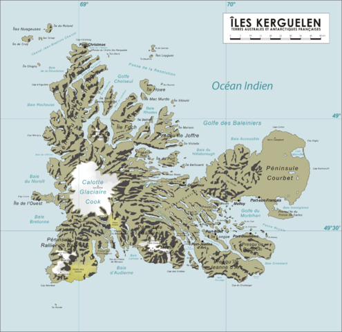
English: Map of the Kerguelen Islands, French Southern and Antarctic Territories
Deutsch: Karte des Kerguelen-Archipel |
||
| چېسلا | 8 ئاپرېل 2006 (original upload date) | ||
| مەنبە | ئۆز ئەسىرىم | ||
| يازغۇچى | Varp | ||
| ھوقۇق (بۇ ھۆججەتنى قايتىلاپ ئىشلىتىش) |
|
ھۆججەت تارىخى
چېسلا/ۋاقىت چېكىلسە ئەينى ۋاقىتتا كۆرۈلگەن ھۆججەتنى كۆرسىتىدۇ.
| چېسلا/ۋاقىت | كىچىك سۈرەت | ئۆلچەم | ئىشلەتكۈچى | ئىزاھات | |
|---|---|---|---|---|---|
| نۆۋەتتىكى | 13:04, 16 ئۆكتەبىر 2008 | | 1,964 × 1,906 (337 KB) | Ralf Roletschek | {{Information |Description= |Source= |Date= |Author= |Permission= |other_versions= }} |
| 07:40, 13 ئاپرېل 2006 |  | 1,964 × 1,906 (904 KB) | Varp~commonswiki | ||
| 07:41, 12 ئاپرېل 2006 |  | 1,964 × 1,906 (866 KB) | Varp~commonswiki | ||
| 10:14, 9 ئاپرېل 2006 |  | 1,964 × 1,906 (866 KB) | Varp~commonswiki | ||
| 14:52, 8 ئاپرېل 2006 |  | 1,964 × 1,906 (853 KB) | Varp~commonswiki | *Map of the Kerguelen Islands, French Southern and Antarctic Territories *drawn by varp |
ھۆججەت ئىشلىتىلىشى
تۆۋەندىكى بەت بۇ ھۆججەتنى ئىشلىتىدۇ:
ئورتاق ھۆججەت ئىشلىتىلىشى
تۆۋەندىكى باشقا ۋىكىلار بۇ ھۆججەتنى ئىشلىتىدۇ:
- als.wikipedia.org دىكى ئىشلىتىشى
- ar.wikipedia.org دىكى ئىشلىتىشى
- da.wikipedia.org دىكى ئىشلىتىشى
- de.wikipedia.org دىكى ئىشلىتىشى
- de.wikivoyage.org دىكى ئىشلىتىشى
- de.wiktionary.org دىكى ئىشلىتىشى
- el.wikipedia.org دىكى ئىشلىتىشى
- en.wikipedia.org دىكى ئىشلىتىشى
- es.wikipedia.org دىكى ئىشلىتىشى
- et.wikipedia.org دىكى ئىشلىتىشى
- frr.wikipedia.org دىكى ئىشلىتىشى
- fr.wikipedia.org دىكى ئىشلىتىشى
- gag.wikipedia.org دىكى ئىشلىتىشى
- gl.wikipedia.org دىكى ئىشلىتىشى
- hr.wikipedia.org دىكى ئىشلىتىشى
- hu.wikipedia.org دىكى ئىشلىتىشى
- id.wikipedia.org دىكى ئىشلىتىشى
- ie.wikipedia.org دىكى ئىشلىتىشى
- is.wikipedia.org دىكى ئىشلىتىشى
- ka.wikipedia.org دىكى ئىشلىتىشى
- lt.wikipedia.org دىكى ئىشلىتىشى
- nds.wikipedia.org دىكى ئىشلىتىشى
- nn.wikipedia.org دىكى ئىشلىتىشى
- no.wikipedia.org دىكى ئىشلىتىشى
- pl.wikipedia.org دىكى ئىشلىتىشى
- pnb.wikipedia.org دىكى ئىشلىتىشى
- ro.wikipedia.org دىكى ئىشلىتىشى
- sk.wikipedia.org دىكى ئىشلىتىشى
- sr.wikipedia.org دىكى ئىشلىتىشى
- sv.wikipedia.org دىكى ئىشلىتىشى
- uk.wikipedia.org دىكى ئىشلىتىشى
- ur.wikipedia.org دىكى ئىشلىتىشى
- vi.wikipedia.org دىكى ئىشلىتىشى
- war.wikipedia.org دىكى ئىشلىتىشى
- zh.wikipedia.org دىكى ئىشلىتىشى