
ھۆججەت:LocationSouthGeorgiaAndSouthSandwichIslands.png
يۇقىرىراق پەرق ئېتىش نىسبىتى يوق.
LocationSouthGeorgiaAndSouthSandwichIslands.png (182 × 115 پىكسېل، ھۆججەت چوڭلۇقى: 5 KB، MIME تىپى: image/png)
ئۈزۈندە
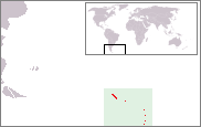
Location map of South Georgia and the South Sandwich Islands. Created by nl:User:Bemoeial based on GFDL-map of en:User:Vardion of Image:LocationFalklandIslands.png.
ئىجازەت

|
Permission is granted to copy, distribute and/or modify this document under the terms of the GNU Free Documentation License, Version 1.2 or any later version published by the Free Software Foundation; with no Invariant Sections, no Front-Cover Texts, and no Back-Cover Texts. A copy of the license is included in the section entitled GNU Free Documentation License. |
| This file is licensed under the Creative Commons Attribution-Share Alike 3.0 Unported license. | ||
| ||
| This licensing tag was added to this file as part of the GFDL licensing update. |
holis
ھۆججەت تارىخى
چېسلا/ۋاقىت چېكىلسە ئەينى ۋاقىتتا كۆرۈلگەن ھۆججەتنى كۆرسىتىدۇ.
| چېسلا/ۋاقىت | كىچىك سۈرەت | ئۆلچەم | ئىشلەتكۈچى | ئىزاھات | |
|---|---|---|---|---|---|
| نۆۋەتتىكى | 15:49, 19 نويابىر 2014 | | 182 × 115 (5 KB) | Kontrollstellekundl | cropped and highlighted |
| 11:00, 26 سىنتەبىر 2005 |  | 250 × 115 (5 KB) | Bemoeial~commonswiki | Location map of South Georgia and the South Sandwich Islands. Created by ;nl:Gebruiker:Bemoeial based on GFDL-map of en:User:Vardion of Image:LocationFalklandIslands.png. |
ھۆججەت ئىشلىتىلىشى
تۆۋەندىكى بەت بۇ ھۆججەتنى ئىشلىتىدۇ:
ئورتاق ھۆججەت ئىشلىتىلىشى
تۆۋەندىكى باشقا ۋىكىلار بۇ ھۆججەتنى ئىشلىتىدۇ:
- ang.wikipedia.org دىكى ئىشلىتىشى
- ar.wikipedia.org دىكى ئىشلىتىشى
- arz.wikipedia.org دىكى ئىشلىتىشى
- az.wikipedia.org دىكى ئىشلىتىشى
- ba.wikipedia.org دىكى ئىشلىتىشى
- be.wikipedia.org دىكى ئىشلىتىشى
- bjn.wikipedia.org دىكى ئىشلىتىشى
- bn.wikipedia.org دىكى ئىشلىتىشى
- bs.wikipedia.org دىكى ئىشلىتىشى
- ceb.wikipedia.org دىكى ئىشلىتىشى
- de.wikipedia.org دىكى ئىشلىتىشى
- dsb.wikipedia.org دىكى ئىشلىتىشى
- el.wikipedia.org دىكى ئىشلىتىشى
- en.wikipedia.org دىكى ئىشلىتىشى
- eo.wikipedia.org دىكى ئىشلىتىشى
- es.wikipedia.org دىكى ئىشلىتىشى
- et.wikipedia.org دىكى ئىشلىتىشى
- fa.wikipedia.org دىكى ئىشلىتىشى
- fr.wikipedia.org دىكى ئىشلىتىشى
- gcr.wikipedia.org دىكى ئىشلىتىشى
- he.wikivoyage.org دىكى ئىشلىتىشى
- hr.wikipedia.org دىكى ئىشلىتىشى
- hu.wiktionary.org دىكى ئىشلىتىشى
- id.wikipedia.org دىكى ئىشلىتىشى
- incubator.wikimedia.org دىكى ئىشلىتىشى
- is.wikipedia.org دىكى ئىشلىتىشى
- it.wikinews.org دىكى ئىشلىتىشى
- ja.wikipedia.org دىكى ئىشلىتىشى
- kk.wikipedia.org دىكى ئىشلىتىشى
- kw.wikipedia.org دىكى ئىشلىتىشى
- lij.wikipedia.org دىكى ئىشلىتىشى
- li.wikipedia.org دىكى ئىشلىتىشى
- lv.wikipedia.org دىكى ئىشلىتىشى
- mk.wikipedia.org دىكى ئىشلىتىشى
- mr.wikipedia.org دىكى ئىشلىتىشى
- ms.wikipedia.org دىكى ئىشلىتىشى
- mt.wikipedia.org دىكى ئىشلىتىشى
- nn.wikipedia.org دىكى ئىشلىتىشى
- nov.wikipedia.org دىكى ئىشلىتىشى
- no.wikipedia.org دىكى ئىشلىتىشى
- oc.wikipedia.org دىكى ئىشلىتىشى
View more global usage of this file.