
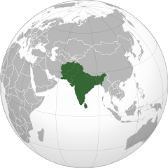
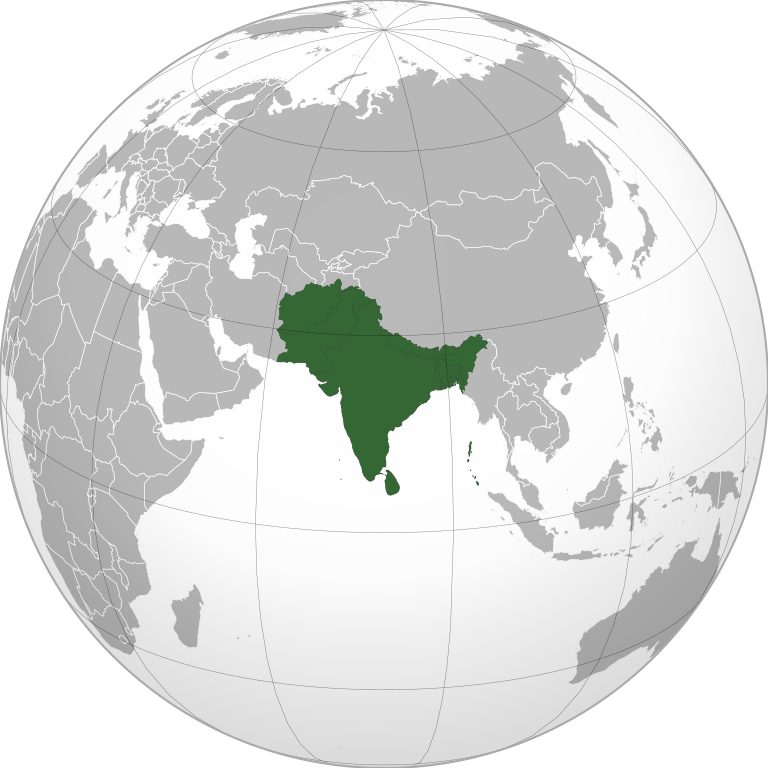
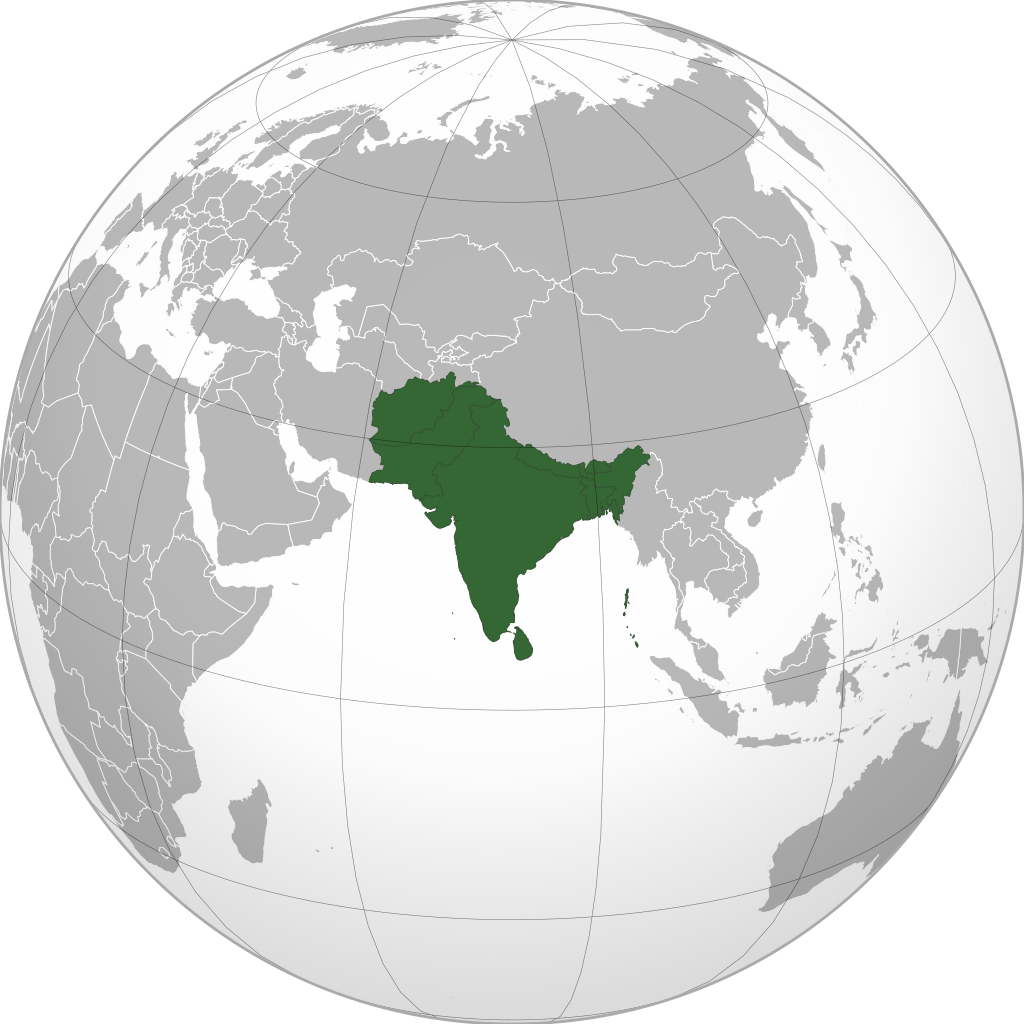
ھۆججەت:South Asia (orthographic projection) without national boundaries.svg

Size of this PNG preview of this SVG file: 550 × 550 پىكسېل. باشقا چوڭلۇقى: 240 × 240 پىكسېل | 480 × 480 پىكسېل | 768 × 768 پىكسېل | 1,024 × 1,024 پىكسېل | 2,048 × 2,048 پىكسېل.
ئەسلى ھۆججەت (SVG ھۆججىتى، ئاتاقتىكى چوڭلۇقى 550 × 550 نۇقتا، ھۆججەت چوڭلۇقى: 2.8 MB)
ئۈزۈندە
| چۈشەندۈرۈش |
English: South Asia |
||
| چېسلا | (UTC) | ||
| مەنبە | |||
| يازغۇچى | user:Serg!o | ||
| Other versions |
.svg) |
||
| SVG genesis |
|
.svg)
.svg)
.svg)
.svg)
.svg)
.svg)
.svg)
.svg)
.svg)
.svg)
.svg)
.svg)
.svg)
.svg)
.svg)
.svg)
.svg)
.svg)
.svg)
.svg)
.svg)
.svg)
.svg)
.svg)
.svg)
.svg)
.svg)
.svg)
.svg)
.svg)
.svg)
.svg)
.svg)
.svg)
.svg)
.svg)
.svg)
.svg)
.svg)
.svg)
.svg)
.svg)
.svg)
.svg)
.svg)
.svg)
.svg)
.svg)
.svg)
.svg)
.svg)
.svg)
.svg)
.svg)
.svg)
.svg)
.svg)
.svg)
.svg)
.svg)
.svg)
.svg)
.svg)
.svg)
.svg)
.svg)
.svg)
.svg)
.svg)
.svg)
.svg)
.svg)
.svg)

.svg)

.svg)

.svg)
.svg)
.svg)
.svg)
.svg)
.svg)
.svg)


.svg)
.svg)
.svg)
.svg)
.svg)
.svg)
.svg)

.svg)
.svg)
.svg)
.svg)
.svg)
.svg)
.svg)
.svg)
.svg)

.svg)
.svg)
.svg)
.svg)
.svg)
.svg)
.svg)
_without_national_boundaries.svg)
.svg)
.svg)
.svg)
.svg)
.svg)
.svg)

.svg)
.svg)
.png)
.svg)
.svg)
.svg)
.svg)

.svg)
.svg)
.svg)
.svg)
.svg)
.svg)
.svg)
.svg)
.svg)
.svg)
.svg)

.svg)
.svg)
.svg)
.svg)
.svg)
.svg)
.svg)
.svg)
.svg)

.svg)
.svg)

.svg)
.svg)
.svg)
.svg)
.svg)
.svg)
.svg)
.svg)
.svg)
.svg)
.svg)
.svg)
.svg)
.svg)
.svg)
.svg)
.svg)
.svg)
.svg)
.svg)
.svg)
.svg)
.svg)
.svg)
.svg)
.svg)
.svg)
_-_Crimea_disputed.svg)
.svg)
.svg)
.svg)
.svg)
.svg)
.svg)
.svg)
.svg)
.svg)
.svg)
.svg)
_political.svg)
.svg)
.svg)
.svg)
.svg)
_-_Crimea_disputed_-_no_borders.svg)
.svg)
.svg)
.svg)
.svg)
.svg)
.svg)
.svg)
.svg)
.svg)
.svg)
.svg)

.svg)
.svg)
.svg)

.png)
.svg)
.svg)
.svg)
.svg)
.svg)
.svg)
.svg)
.svg)
.svg)
.svg)
.svg)
.svg)
.svg)
.svg)
.svg)
.svg)
.svg)
.svg)
.svg)
.svg)
.svg)
.svg)
.svg)
.svg)
.svg)
.svg)
.svg)
.svg)
.svg)
.svg)
.svg)
.svg)
.svg)
.svg)
.png)
.svg)
.svg)
.svg)
_(orthographic_projection).png)
_without_national_boundaries.svg)
ئىجازەت
I, the copyright holder of this work, hereby publish it under the following licenses:
This file is licensed under the Creative Commons Attribution-Share Alike 3.0 Unported license.
- سىز ئەركىن:
- بەھىرلەش – to copy, distribute and transmit the work
- ئۆزگەرتىش – ئىجادىي ئەسەر
- تۆۋەندىكى شەرتلەرگە چوقۇم ئەمەل قىلىڭ:
- ئىمزا – You must give appropriate credit, provide a link to the license, and indicate if changes were made. You may do so in any reasonable manner, but not in any way that suggests the licensor endorses you or your use.
- ئوخشاش ئۇسۇلدا بەھىرلەش – If you remix, transform, or build upon the material, you must distribute your contributions under the same or compatible license as the original.

|
Permission is granted to copy, distribute and/or modify this document under the terms of the GNU Free Documentation License, Version 1.2 or any later version published by the Free Software Foundation; with no Invariant Sections, no Front-Cover Texts, and no Back-Cover Texts. A copy of the license is included in the section entitled GNU Free Documentation License. |
|
|
Permission is granted to copy, distribute and/or modify this document under the terms of the GNU Free Documentation License, Version 1.2 or any later version published by the Free Software Foundation; with no Invariant Sections, no Front-Cover Texts, and no Back-Cover Texts. A copy of the license is included in the section entitled GNU Free Documentation License. |
You may select the license of your choice.
The map has been created with the Generic Mapping Tools: https://www.generic-mapping-tools.org/ using one or more of these public-domain datasets for the relief:
|
|
|
Permission is granted to copy, distribute and/or modify this document under the terms of the GNU Free Documentation License, Version 1.2 or any later version published by the Free Software Foundation; with no Invariant Sections, no Front-Cover Texts, and no Back-Cover Texts. A copy of the license is included in the section entitled GNU Free Documentation License. |
ھۆججەت تارىخى
چېسلا/ۋاقىت چېكىلسە ئەينى ۋاقىتتا كۆرۈلگەن ھۆججەتنى كۆرسىتىدۇ.
_without_national_boundaries.svg&dir=prev)
_without_national_boundaries.svg&offset=20200819201055)
_without_national_boundaries.svg&offset=&limit=20)
_without_national_boundaries.svg&offset=&limit=50)
_without_national_boundaries.svg&offset=&limit=100)
_without_national_boundaries.svg&offset=&limit=250)
_without_national_boundaries.svg&offset=&limit=500)
| چېسلا/ۋاقىت | كىچىك سۈرەت | ئۆلچەم | ئىشلەتكۈچى | ئىزاھات | |
|---|---|---|---|---|---|
| نۆۋەتتىكى | 06:10, 12 نويابىر 2022 | | 550 × 550 (2.8 MB) | Sourav Bapuli | Added Siachen Glacier as requested by {{u|King Prithviraj II}} |
| 17:56, 1 يانۋار 2021 |  | 553 × 553 (216 KB) | Sbb1413 | Converted to Plain SVG. | |
| 17:52, 1 يانۋار 2021 |  | 553 × 553 (216 KB) | Sbb1413 | The previous attempt failed, another attempt of correcting the errors. | |
| 17:48, 1 يانۋار 2021 |  | 553 × 553 (179 KB) | Sbb1413 | Corrected W3C error. | |
| 16:23, 24 ئاۋغۇست 2020 |  | 553 × 553 (284 KB) | Prosfilaes | Reverted to version as of 01:09, 24 August 2020 (UTC); consistency with historical use of this file. Upload distinct new versions to a new name | |
| 12:12, 24 ئاۋغۇست 2020 |  | 744 × 1,052 (540 KB) | Xerxes1985 | Reverted to version as of 19:21, 22 August 2020 (UTC) It isn’t meant to be the important feature, it’s portrayed in a lighter colour due to its position as a link between south and Central Asia, or do you think Afghanistan has the same position in South Asia as Bangladesh, Pakistan or India ? | |
| 01:09, 24 ئاۋغۇست 2020 |  | 553 × 553 (284 KB) | Aditya Kabir | Reverted to version as of 20:10, 21 August 2020 (UTC) The South Asian map doesn't need Afghanistan as the most important feature | |
| 19:21, 22 ئاۋغۇست 2020 |  | 744 × 1,052 (540 KB) | Xerxes1985 | Reverted to version as of 20:10, 19 August 2020 (UTC) Thats why it’s still in the map and not completely removed | |
| 20:10, 21 ئاۋغۇست 2020 |  | 553 × 553 (284 KB) | PersianV | Reverted to version as of 18:07, 11 May 2017 (UTC) Reverted, technically considered South Asian | |
| 20:10, 19 ئاۋغۇست 2020 |  | 744 × 1,052 (540 KB) | Xerxes1985 | Afghanistan in a lighter colour |
ھۆججەت ئىشلىتىلىشى
تۆۋەندىكى بەت بۇ ھۆججەتنى ئىشلىتىدۇ:
ئورتاق ھۆججەت ئىشلىتىلىشى
تۆۋەندىكى باشقا ۋىكىلار بۇ ھۆججەتنى ئىشلىتىدۇ:
- af.wikipedia.org دىكى ئىشلىتىشى
- am.wikipedia.org دىكى ئىشلىتىشى
- ar.wikipedia.org دىكى ئىشلىتىشى
- arz.wikipedia.org دىكى ئىشلىتىشى
- ast.wikipedia.org دىكى ئىشلىتىشى
- azb.wikipedia.org دىكى ئىشلىتىشى
- az.wikipedia.org دىكى ئىشلىتىشى
- ban.wikipedia.org دىكى ئىشلىتىشى
- ba.wikipedia.org دىكى ئىشلىتىشى
- bcl.wikipedia.org دىكى ئىشلىتىشى
- be-tarask.wikipedia.org دىكى ئىشلىتىشى
- be.wikipedia.org دىكى ئىشلىتىشى
- bg.wikipedia.org دىكى ئىشلىتىشى
- bh.wikipedia.org دىكى ئىشلىتىشى
- bjn.wikipedia.org دىكى ئىشلىتىشى
- bn.wikipedia.org دىكى ئىشلىتىشى
- বাংলাদেশ
- ভারত
- পাকিস্তান
- নেপাল
- মালদ্বীপ
- আফগানিস্তান
- ভুটান
- দক্ষিণ এশীয় আঞ্চলিক সহযোগিতা সংস্থা
- দক্ষিণ এশিয়া
- শ্রীলঙ্কা
- টেমপ্লেট:দক্ষিণ এশিয়ার দেশসমূহ
- ভারতের রাজনীতি
- ভারতের সংস্কৃতি
- আলাপ:নিয়াজ মোরশেদ
- আলাপ:শ্রীলঙ্কা
- ব্যবহারকারী:Jayantanth/Sandbox
- ২০১২ সাফ মহিলা চ্যাম্পিয়নশিপ
- মালদ্বীপের বৈদেশিক সম্পর্ক
- প্রবেশদ্বার:শ্রীলঙ্কা
- প্রবেশদ্বার:পাকিস্তান
- প্রবেশদ্বার:নেপাল
- প্রবেশদ্বার:পাকিস্তান/প্রবেশদ্বারসমূহ
View more global usage of this file.
_without_national_boundaries.svg)
_without_national_boundaries.svg)