
ھۆججەت:Koppen-Geiger Map ARG present.svg

Size of this PNG preview of this SVG file: 512 × 423 پىكسېل. باشقا چوڭلۇقى: 291 × 240 پىكسېل | 581 × 480 پىكسېل | 930 × 768 پىكسېل | 1,240 × 1,024 پىكسېل | 2,479 × 2,048 پىكسېل.
ئەسلى ھۆججەت (SVG ھۆججىتى، ئاتاقتىكى چوڭلۇقى 512 × 423 نۇقتا، ھۆججەت چوڭلۇقى: 1.21 MB)
ئۈزۈندە
| چۈشەندۈرۈش |
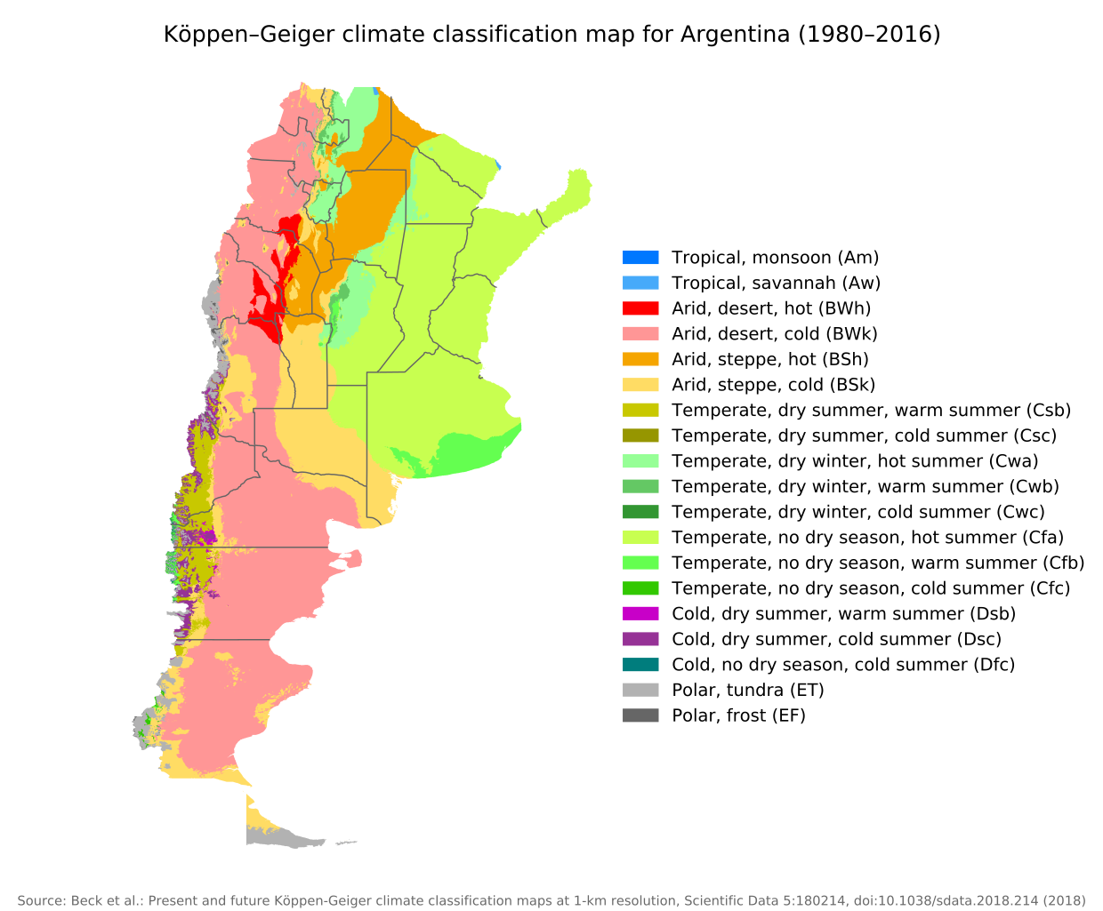
English: Köppen–Geiger climate classification map for Argentina |
| چېسلا | |
| مەنبە | "Present and future Köppen-Geiger climate classification maps at 1-km resolution". Nature Scientific Data. DOI:10.1038/sdata.2018.214. |
| يازغۇچى | Beck, H.E., Zimmermann, N. E., McVicar, T. R., Vergopolan, N., Berg, A., & Wood, E. F. |
ئىجازەت
This file is licensed under the Creative Commons Attribution 4.0 International license.
- سىز ئەركىن:
- بەھىرلەش – to copy, distribute and transmit the work
- ئۆزگەرتىش – ئىجادىي ئەسەر
- تۆۋەندىكى شەرتلەرگە چوقۇم ئەمەل قىلىڭ:
- ئىمزا – You must give appropriate credit, provide a link to the license, and indicate if changes were made. You may do so in any reasonable manner, but not in any way that suggests the licensor endorses you or your use.
| Camera location | | View this and other nearby images on: OpenStreetMap |
|---|
ھۆججەت تارىخى
چېسلا/ۋاقىت چېكىلسە ئەينى ۋاقىتتا كۆرۈلگەن ھۆججەتنى كۆرسىتىدۇ.
| چېسلا/ۋاقىت | كىچىك سۈرەت | ئۆلچەم | ئىشلەتكۈچى | ئىزاھات | |
|---|---|---|---|---|---|
| نۆۋەتتىكى | 09:14, 8 سىنتەبىر 2020 | | 512 × 423 (1.21 MB) | Allice Hunter | Provinces and adjustments |
| 15:44, 17 ئىيۇل 2020 |  | 1,208 × 850 (1.51 MB) | JPLema | Reverted to version as of 21:36, 15 June 2020 (UTC) | |
| 15:43, 17 ئىيۇل 2020 |  | 840 × 812 (1.45 MB) | JPLema | reducción de tamaño | |
| 21:36, 15 ئىيۇن 2020 |  | 1,208 × 850 (1.51 MB) | JPLema | Reverted to version as of 03:03, 26 November 2018 (UTC) | |
| 13:02, 15 ئىيۇن 2020 |  | 696 × 1,006 (1.34 MB) | JPLema | reduje el ancho y aumenté la altura | |
| 03:03, 26 نويابىر 2018 |  | 1,208 × 850 (1.51 MB) | NVergopolan | {{Information |Description={{en| Köppen–Geiger climate classification map for Argentina}}|date=2018-11-06|source={{cite journal | journal=Nature Scientific Data |doi=10.1038/sdata.2018.214}}|author=Beck, H.E., Zimmermann, N. E., McVicar, T. R., Vergopolan, N., Berg, A., & Wood, E. F.|permission=|other_versions=|other_fields=}}{{Cc-by-4.0}}{{Location|-38.42003918|-63.58480835}}Category:Köppen-Geiger Climate Classification MapsCategory:present climate (1980–2016)Category:Argentina[[... |
ھۆججەت ئىشلىتىلىشى
بۇ ھۆججەتنى ئىشلەتكەن بەت يوق.
ئورتاق ھۆججەت ئىشلىتىلىشى
تۆۋەندىكى باشقا ۋىكىلار بۇ ھۆججەتنى ئىشلىتىدۇ:
- bg.wikipedia.org دىكى ئىشلىتىشى
- ckb.wikipedia.org دىكى ئىشلىتىشى
- en.wikipedia.org دىكى ئىشلىتىشى
- id.wikipedia.org دىكى ئىشلىتىشى
- ja.wikipedia.org دىكى ئىشلىتىشى
- km.wikipedia.org دىكى ئىشلىتىشى
- pt.wikipedia.org دىكى ئىشلىتىشى
- ru.wikipedia.org دىكى ئىشلىتىشى
- sr.wikipedia.org دىكى ئىشلىتىشى
- tr.wikipedia.org دىكى ئىشلىتىشى
- uk.wikipedia.org دىكى ئىشلىتىشى