
ھۆججەت:AfricaLocation.svg

Size of this PNG preview of this SVG file: 463 × 236 پىكسېل. باشقا چوڭلۇقى: 320 × 163 پىكسېل | 640 × 326 پىكسېل | 1,024 × 522 پىكسېل | 1,280 × 652 پىكسېل | 2,560 × 1,305 پىكسېل.
ئەسلى ھۆججەت (SVG ھۆججىتى، ئاتاقتىكى چوڭلۇقى 463 × 236 نۇقتا، ھۆججەت چوڭلۇقى: 290 KB)
ئۈزۈندە
| چۈشەندۈرۈش |
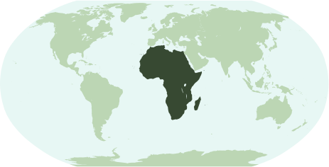
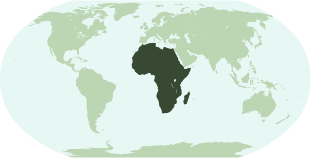
English: Map showing the location of the continent of Africa (including indian ocean islands near Madagascar).
Français : Une carte pour démontrer la location du continent de l'Afrique (avec des îles d'océan indien près de Madagasque).
Interlingua: Un Mapa monstrante le location del continente de Africa (con insulas del oceano indian juxta Madagascar). |
| چېسلا | |
| مەنبە | ئۆز ئەسىرىم |
| يازغۇچى | Notscott |
ئىجازەت
| I, the copyright holder of this work, release this work into the public domain. This applies worldwide. In some countries this may not be legally possible; if so: I grant anyone the right to use this work for any purpose, without any conditions, unless such conditions are required by law. |
ھۆججەت تارىخى
چېسلا/ۋاقىت چېكىلسە ئەينى ۋاقىتتا كۆرۈلگەن ھۆججەتنى كۆرسىتىدۇ.
| چېسلا/ۋاقىت | كىچىك سۈرەت | ئۆلچەم | ئىشلەتكۈچى | ئىزاھات | |
|---|---|---|---|---|---|
| نۆۋەتتىكى | 01:23, 15 يانۋار 2007 | | 463 × 236 (290 KB) | Notscott | {{en|Map showing the location of the continent of Africa (including indian ocean islands near Madagascar).}} {{fr|Une carte pour démontrer la location du continent de l'Afrique (avec des îles d'océan indien près de Madagasque).}} {{ia|Un Mapa monstran |
| 23:50, 14 يانۋار 2007 |  | 463 × 236 (290 KB) | Notscott | {{en|Map showing the location of the continent of Africa (including indian ocean islands near Madagascar).}} {{fr|Une carte pour démontrer la location du continent d'Afrique (avec des îles d'océan indien près de Madagasque).}} {{ia|Un Mapa monstrante |
ھۆججەت ئىشلىتىلىشى
تۆۋەندىكى 59 بەت بۇ ھۆججەتنى ئىشلىتىدۇ:
- ئافرىقا
- ئالجىرىيە
- ئانگولا
- ئوتتۇرا ئافرىقا
- ئوتتۇرا ئافرىقا جۇمھۇرىيىتى
- ئۇگاندا
- ئېرىترېيە
- ئېفىئوپىيە
- ئېكۋاتور گۋىنېيىسى
- بوتسۋانا
- بۇركىنا فاسو
- بۇرۇندى
- بېنىن
- تانزانىيە
- توگو
- تۇنىس
- جىبۇتى
- جەنۇبىي ئافرىقا
- رۋاندا
- زامبىيە
- زىمبابۋې
- سان تومې ۋە پرىنسىپې
- سومالى
- سيېررا لېئونې
- سۇدان
- سۋازىلېند
- سېنېگال
- سېيشېل ئاراللىرى
- شىمالىي ئافرىقا
- شەرقىي ئافرىقا
- غەربىي ئافرىقا
- كامېرۇن
- كومور ئاراللىرى
- كونگو جۇمھۇرىيىتى
- كونگو دېموكراتىك جۇمھۇرىيىتى
- كېنىيە
- لىبېرىيە
- لىۋىيە
- لېسوتو
- ماداگاسكار
- ماراكەش
- مالاۋى
- مالى
- ماۋرىتانىيە
- ماۋرىتىئۇس
- موزامبىك
- مىسىر
- نامىبىيە
- نىگېر
- نىگېرىيە
- يېشىل تۇمشۇق ئاراللىرى
- پىل چىشى قىرغىغى
- چاد
- گابون
- گامبىيە
- گانا جۇمھۇرىيىتى
- گۋىنىيە
- گۋىنېيە بىسسائۇ
- قېلىپ:ئافرىقا
ئورتاق ھۆججەت ئىشلىتىلىشى
تۆۋەندىكى باشقا ۋىكىلار بۇ ھۆججەتنى ئىشلىتىدۇ:
- arz.wikipedia.org دىكى ئىشلىتىشى
- جنوب السودان
- ليبيا
- مصر
- جمهورية كونجو الديموقراطيه
- زيمبابوى
- اسواتينى
- سينيجال
- رواندا
- اوجاندا
- ثيويتا
- الجزاير
- سانت هيلينا
- قالب:افريقيا
- قالب:امريكا الجنوبية/شرح
- قالب:شرح استعمال قوالب القارات
- اريتريا
- شمال افريقيا
- شرق افريقيا
- وسط افريقيا
- كوت ديفوار
- جيبوتى
- بوركينا فاسو
- بوتسوانا
- افريقيا الوسطى
- الاحزاب السياسية فى تونس
- الاحزاب السياسية فى جنوب السودان
- الاحزاب السياسية فى السودان
- الاحزاب السياسيه فى المغرب
- جمهورية الكونجو
- جينيا
- جامبيا
- لغات مصر
- قالب:الاحزاب السياسيه فى دول افريقيا
- قالب:اناشيد دول افريقيا الوطنيه
- قالب:جامعات افريقيا
- avk.wikipedia.org دىكى ئىشلىتىشى
- bi.wikipedia.org دىكى ئىشلىتىشى
- bm.wikipedia.org دىكى ئىشلىتىشى
- bpy.wikipedia.org دىكى ئىشلىتىشى
- cbk-zam.wikipedia.org دىكى ئىشلىتىشى
- ch.wikipedia.org دىكى ئىشلىتىشى
- en.wikipedia.org دىكى ئىشلىتىشى
View more global usage of this file.