
ھۆججەت:GökturksAD551-572.png

بۇ ئالدىن كۆزىتىشنىڭ چوڭلۇقى: 800 × 467 پىكسېل. باشقا چوڭلۇقى: 320 × 187 پىكسېل | 640 × 373 پىكسېل | 1,024 × 597 پىكسېل | 1,644 × 959 پىكسېل.
ئەسلى ھۆججەت (1,644 × 959 پىكسېل، ھۆججەت چوڭلۇقى: 28 KB، MIME تىپى: image/png)
ئۈزۈندە
| چۈشەندۈرۈش |
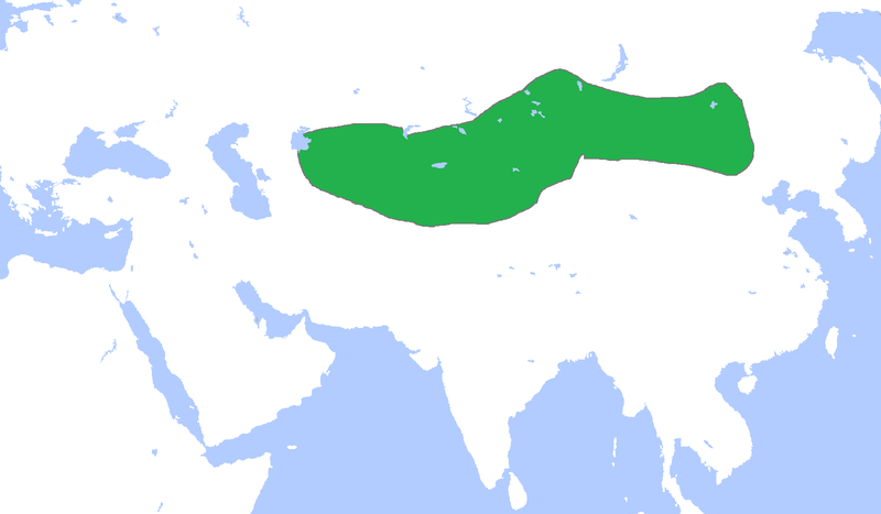
English: Locator map of the Gökturks, c. 551-572.
(Partially based on Atlas of World History (2007) - The World 500-750, map) |
| چېسلا | |
| مەنبە | ئۆز ئەسىرىم |
| يازغۇچى | Gabagool |
ئىجازەت
I, the copyright holder of this work, hereby publish it under the following license:
This file is licensed under the Creative Commons Attribution 3.0 Unported license.
- سىز ئەركىن:
- بەھىرلەش – to copy, distribute and transmit the work
- ئۆزگەرتىش – ئىجادىي ئەسەر
- تۆۋەندىكى شەرتلەرگە چوقۇم ئەمەل قىلىڭ:
- ئىمزا – You must give appropriate credit, provide a link to the license, and indicate if changes were made. You may do so in any reasonable manner, but not in any way that suggests the licensor endorses you or your use.
ھۆججەت تارىخى
چېسلا/ۋاقىت چېكىلسە ئەينى ۋاقىتتا كۆرۈلگەن ھۆججەتنى كۆرسىتىدۇ.
| چېسلا/ۋاقىت | كىچىك سۈرەت | ئۆلچەم | ئىشلەتكۈچى | ئىزاھات | |
|---|---|---|---|---|---|
| نۆۋەتتىكى | 14:36, 18 مارت 2021 | | 1,644 × 959 (28 KB) | HistoryofIran | rv, user is banned |
| 14:08, 18 مارت 2021 |  | 1,644 × 959 (54 KB) | TurkicHeritage | Reverted to version as of 12:36, 18 March 2021 (UTC) | |
| 12:43, 18 مارت 2021 |  | 1,644 × 959 (28 KB) | HistoryofIran | rv, vandalism | |
| 12:36, 18 مارت 2021 |  | 1,644 × 959 (54 KB) | HistoryofHumann | Reverted to the original uploaded version. Changes without valid source will be reverted. | |
| 01:30, 18 مارت 2021 |  | 1,644 × 959 (28 KB) | HistoryofIran | Reverted to version as of 10:51, 26 July 2013 (UTC) | |
| 23:17, 16 مارت 2021 |  | 1,644 × 959 (54 KB) | HistoryofHumann | This version is the correct one. The changes are based on most reliable sources | |
| 10:51, 26 ئىيۇل 2013 |  | 1,644 × 959 (28 KB) | HistoryofIran | Fixed map borders, they never controlled so much land down south. | |
| 15:37, 23 ئاپرېل 2009 |  | 1,644 × 959 (54 KB) | Gabagool | {{Information |Description={{en|1=Locator map of the Gökturks, c. 551-572. (Partially based on ''Atlas of World History'' (2007) - The World 500-750, map)}} |Source=Own work by uploader |Author=Gabagool / Jarle Grøhn |Date=2009-04-23 |
ھۆججەت ئىشلىتىلىشى
تۆۋەندىكى 2 بەت بۇ ھۆججەتنى ئىشلىتىدۇ:
ئورتاق ھۆججەت ئىشلىتىلىشى
تۆۋەندىكى باشقا ۋىكىلار بۇ ھۆججەتنى ئىشلىتىدۇ:
- ar.wikipedia.org دىكى ئىشلىتىشى
- ast.wikipedia.org دىكى ئىشلىتىشى
- azb.wikipedia.org دىكى ئىشلىتىشى
- az.wikipedia.org دىكى ئىشلىتىشى
- ba.wikipedia.org دىكى ئىشلىتىشى
- de.wikipedia.org دىكى ئىشلىتىشى
- el.wikipedia.org دىكى ئىشلىتىشى
- en.wikipedia.org دىكى ئىشلىتىشى
- es.wikipedia.org دىكى ئىشلىتىشى
- fa.wikipedia.org دىكى ئىشلىتىشى
- fi.wikipedia.org دىكى ئىشلىتىشى
- fr.wikipedia.org دىكى ئىشلىتىشى
- hi.wikipedia.org دىكى ئىشلىتىشى
- hr.wikipedia.org دىكى ئىشلىتىشى
- hu.wikipedia.org دىكى ئىشلىتىشى
- hy.wikipedia.org دىكى ئىشلىتىشى
- id.wikipedia.org دىكى ئىشلىتىشى
- id.wikibooks.org دىكى ئىشلىتىشى
- it.wikipedia.org دىكى ئىشلىتىشى
- ja.wikipedia.org دىكى ئىشلىتىشى
- ko.wikipedia.org دىكى ئىشلىتىشى
View more global usage of this file.